


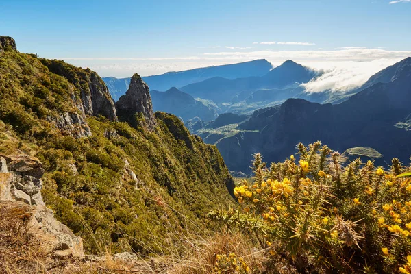
A true natural balcony above the Cirque of Mafate, the Maïdo is one of Réunion’s most spectacular viewpoints. From here you can admire the sheer ramparts, Mafate’s hamlets, the Grand Bénare and, on clear days, all the way to the Piton des Neiges. It’s also a prime area for hiking (ridge walks, descents into Mafate) and a favourite spot for sunrise.
Where is the Maïdo and how do you get there?
The Maïdo viewpoint towers over the west coast, above Saint-Paul. Access is via the Route Forestière du Maïdo through the Plateau des Tamarins.
-
Access: well-surfaced road with a series of hairpins (drive carefully uphill).
-
Parking: at the viewpoint and nearby picnic areas.
-
Tip: set off early in the morning (ideally before 8 am) for clear skies; clouds often rise by late morning.
Maïdo: history & toponymy
The name “Maïdo” likely comes from Malagasy, meaning “burnt”, a reminder of the savanna fires that once marked the western highlands. From a lookout used to monitor controlled burns to a major panoramic site, the Maïdo is now an emblematic gateway to the National Park and the UNESCO-listed “Pitons, Cirques and Ramparts.”
Panorama: what you see from the viewpoint
-
Cirque of Mafate: Roche Plate, Îlet des Orangers, and sometimes La Nouvelle in the distance.
-
Ridges: Grand Bénare, Gros Morne, Piton des Neiges (visibility permitting).
-
West Coast: the Indian Ocean shimmers below, with a unique mountain-to-lagoon contrast.
Hikes starting from the Maïdo (selection)
Times and difficulties are indicative, and depend on weather and fitness. Mountain gear, water and a map are essential.
-
Maïdo ridge → Grand Bénare (out & back)
High-altitude route along the ramparts with XXL views over Mafate.
Distance/Time: ~12–16 km, 5–7 h return. Elevation gain: ~700–900 m+. Difficulty: strenuous (high mountain). -
Descent from the Maïdo via La Brèche → Roche Plate (Mafate)
A classic, very steep descent with steps, switchbacks and rocky sections.
Time: 3–4 h down; 4–6 h back up. Elevation change: ~1,000–1,200 m±. Difficulty: demanding (knees, heat). -
Roche Plate → Trois Roches (from the Mafate floor)
Extends the adventure along the Rivière des Galets.
Time: 3–4 h return from Roche Plate. Difficulty: moderate. -
Orangers / Bronchard variants (ridges & viewpoints)
Superb secondary lookouts, some airy passages.
Time: 3–5 h depending on the loop. Difficulty: moderate to strenuous.
Pro tip: descend via La Brèche, overnight in a gîte at Roche Plate or Les Orangers, then climb back up early the next morning.
Best time & weather
The Maïdo is worth visiting year-round, with peak attendance in the austral winter. Winter mornings are often clearer and windier; in summer, clouds can build by late morning.
-
Temperatures: cool to cold at sunrise (bring a fleece and windbreaker).
-
Wind: frequent on the ridges; secure hats and camera gear.
-
Rain/fog: possible; keep well back from cliff edges in poor visibility.
Sunrise & astrophotography
The Maïdo is a legendary sunrise spot: at dawn, the ramparts cast long shadows across Mafate. On clear nights, far from coastal lights, it’s also great for stargazing (bring a headlamp and warm layers).
MTB & other activities
The area is known for downhill mountain-bike trails (with professional guiding). Other ideas: picnics beneath tamarind trees and short family walks on the fitted paths near the viewpoint.
Practical tips (safety)
-
Gear: hiking shoes, 2 L water/person, snacks, hat, sunscreen, windbreaker, map/loaded GPS track.
-
Respect the site: stay on waymarked trails, keep away from cliff edges, pack out all litter, respect the quiet and the Mafate hamlets (no roads; supplies by helicopter).
-
If in doubt about the weather: stay around the viewpoint and avoid exposed routes.